Thursday, November 20, 2008

Live Training Seminars by ESRI.....it works at ur workplace

ESRI Live Training Seminars: dont know if many of you know about this. These hour long virtual presentations are designed for those who want GIS training on a focused topic presented live by an ESRI technical expert.

Optioned with an interactive question and answer with the presenter and presented using the broadband connection to the Internet. These are free and need Windows Media Player 9 or higher to webcast.

Keep more track at http://training.esri.com/campus/seminars/index.cfm.


Some useful tips
1Test your connection

If you have never attended a live training seminar, please follow the steps below to ensure you can connect to the presentation. The seminar uses both Windows Media Player and Adobe Flash Player.
  • Go to http://training.esri.com/lts/testpresentation2/index.cfm.
  • Log in with your ESRI global account. If you don't have an ESRI global account, click the Create New Account link. A global account is required in order to attend the seminar.
  • The test presentation window will open in a new window and, in a few seconds, you should see slides and hear music. If you do not, use the resources in the left panel for assistance.


Attend the seminar
  • Go to http://training.esri.com/campus/seminars/index.cfm.
  • Click the Attend Seminar button. The button will be active approximately 30 minutes before the seminar’s scheduled start time.
  • Log in using your ESRI global account. The presentation window will open but it may take up to a minute for you to see the first slide.

See today : ( Match you time )

Editing in ArcGIS 9: Tips and Tricks III
Thursday, November 20, 2008
9:00 a.m., 11:00 a.m., & 3:00 p.m. Pacific Time (US & Canada)
12:00 p.m., 2:00 p.m., & 6:00 p.m. Eastern Time (US & Canada)
5:00 p.m., 7:00 p.m., & 11:00 p.m. UTC/GMT

Monday, November 17, 2008

Poverty Data


What?
The Sedac Ciesin Global Distribution of Poverty site is one of the best portals for downloading poverty related geodata.
The Global Poverty Mapping Project seeks to enhance current understanding of the global distribution of poverty and the geographic and biophysical conditions of where the poor live. Here you can find poverty related data in shp, xls and csv format or create your own map online.

The global data sets include:

Infant Mortality Rates
and

Malnutrition (underweight children), all translated to a common quarter-degree grid.

The sub national data includes:

Small Area Estimate: Consumption-based poverty and inequality measures and related data for subnational administrative units in: Africa, Asia, Europe and Latin America.

Poverty & Food Security Case Studies: Poverty and food security measures for subnational administrative units in: Mexico, Ecuador, Kenya, Malawi, Bangladesh, Sri Lanka and Vietnam.

Unsatisfied Basic Needs: Measures of unmet basic needs for subnational administrative units of numerous countries in Latin America: Argentina, Bolivia, Brazil, Colombia, Ecuador, El Salvador, Guatemala, Honduras, Mexico, Nicaragua, and Peru.

How?
On the top menu click on "Datasets" and choose if you want information (data in xls format), global data (either shp or xls of all country level data) or click on national data. Here, you can download poverty data according to subnational administrative units for each country, in shp format. You can also customize this dataset and then download it in csv format.

If you don't have GIS software, click on "maps" on the main menu and either download existing poverty maps or create your own by navigating to the Sedac Map Client.

Who?
The Poverty Mapping Project at CIESIN (The Center for International Earth Science Information Network) at the Earth Institute at Columbia University is funded by the World Bank’s Japan Policy and Human Resource Development (PHRD) Fund.

When?
This Project was a partnership between CIESIN, the World Bank, and the Earth Institute at Columbia University and was undertaken in 2004-2005.

Thursday, November 6, 2008

UNEP Geo Data Portal


Looking for environmental data? The UNEP Data Portal is a great place to start. In all, there are over 1400 datasets available on the webpage. You can retrieve this data in various formats such as shp, graphs, lists and maps.

Just click on the link above and go to the "search" in the middle of the page. If you leave the search field blank and click "search" you will get the entire dataset. Try typing in things like "fish catch" or "reef" for more specific data overviews. Click the "Preview" button for a map quicklook.
After you select your data, you will be prompted to define time period and format. It´s as easy as that.

If you use the data remember to check the metadata for acknowledgment purposes.

Tuesday, October 21, 2008

Google Trends


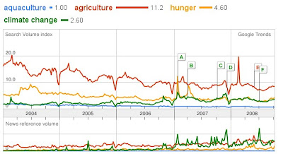
Google Trends is a nice application by Google, demonstrating the number of searches that have been made referring to a certain subject, as well as how many news references have been made. Also, you can see what country the "top searchers" come from.

Another nice feature is that you can compare different subjects. For example, I typed aquaculture, agriculture, hunger, and climate change. Here is the link to this query. The image below illustrates the outcome.


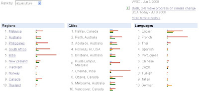
It is also interesting to see that Malaysia is the top "searcher" for aquaculture, as demonstrated below.


While Google writes that you should not base your PHD on this information, as it is still in beta, I do think this an interesting tool which is well worth exploring.

For more information please visit About Google Trends.

Monday, October 20, 2008

Blogs

Reading blogs is a good way to stay on top of things and to know about all the newest technologies out there. I thought I would share some of my favorite GIS related blogs with you. I usually read through them at least once a week.

The Esri Blog is nice because it is very diverse and the blog entries are quite detailed, often with screen shots and click instructions. Esri has several blogs according to subjects. This one shows all entries. It´s a great way to stay on top of the many ArcGIS possibilities and a great place to get ideas for analyses.

There are several blogs regarding free geographic software as well. The Free Geography Tools blog gives a good overview about what is available and it is fun to test the tools demonstrated.

Of course there are also the blogs related to Google Earth and Google Maps. Some interesting ones are Google Maps Mania, Google Lat Long and the Google Earth Blog.

Map Hawk is interesting blog to follow as well. This one is about the way the media uses maps. It´s good for getting some ideas about how to publish maps and in which format.

To have some fun and to inspire some cool ideas, check out the Strange Maps blog.


Thursday, October 16, 2008

Valuing Living Aquatic Resources (LARS) of Wetlands in China


A two-year research project, titled "Valuing the role of living aquatic resources (LARS) in multiple-use, seasonally inundated wetlands in China for improved governance" or usually knowns as brief title "Valuing Aquatic Resources (LARS) of Wetlands in China", is applying an integrated approach for accessing and valuing the role of living aquatic resources (LARS) in wetlands in the Yellow River (Huanghe) basin in China, funded through the Challenge Program for Water and Food (CPWF). This project has been initiated on 01 January 2008 as a collaborative effort between the WorldFish Center (WorldFish) and the Chinese Academy of Fishery Sciences (CAFS), with the cooperation of provincial and local authorities in Shandong and Henan provinces. Identifying the challenge of required working across country boundary, a web site was setup to use as a platform to work together among all research team members and China partners to maintain the web content, shared the project calendar and all related project documents in one place, hosted on one site. To make use the free services provided, the project web site for public viewing and another with restricted access for registered team members only were created using Google Sites, which is one of the application included in Google Apps. For restricted access web site, there is a GIS page, which is one of the research components page, provides the space for GIS team members make announcements, sharing information, and upload files. If you are interested to know more about the GIS technologies/tools we applied for this project, please send your Gmail account to the website administrator (s.teoh@cgiar.org). You will receive an invitation email, so that you can proceed with first login.

Monday, October 13, 2008

Map and Data Search Using Google Earth


Google Earth provides an easy and quick way to search for existing KML´s (Google Earth files) and maps. In the upper left "search" space, type in what you are looking for.

For example, I zoomed in on Zambia and Mozambique and searched for "maps". Placemarks will appear where maps are available. Click on the place marks in order to get the link for retrieving the map. Some maps are in KML format already and can be viewed in Google Earth, like the flood maps created by the ZKI as shown in the image below.


Flood maps as kml overlays by ZKI

Also try typing in other words like "fish" or "rivers". If there is a city or town with "river" in its name, then you will only receive place name suggestions instead of available data or maps. In order to avoid this, try typing in "rivers in Zambia".

FishBase as Google Earth File


The Global Biodiversity Information Facility (GBIF) has large amounts of data related to biodiversity. For an introduction to the capabilities of the Portal, see the online tutorial. Among other datasets you can also download FishBase data in form of a Google Earth File.

For example, I navigated to "countries" in the main menu and then chose Malawi. In the download area I chose "Placemarks for Google Earth (limit 10´000)". A Google Earth file, including the FishBase data is then generated.

Note: You must have Google Earth installed in order to view the Google Earth file.

Thursday, October 9, 2008

FAO GeoNetwork


One of my favorite platforms for retrieving geodata is the Fao GeoNetwork. It may take a while to load the page but the data collection is quite extensive and definitely worth the wait. On the site you can conduct searches of data that you may need. Usually you can download the data straight from the page, which is very convenient. I like the fact, that metadata and screenshot are also provided. This really helps to get an idea of what the data is about, so you are not disappointed after a long download and unzipping process.

For fish related data, type in "fish" Into the "What?" search space on the left hand side and you will receive all data related to fish.
You can also search for fish data relative to the countries, by using the map or by choosing the country from the drop down menu.

The data comes in some of your favorite GIS formats, such as shapefile, grid and geotiff. If you use this data, please make sure to reference the right organization. Reference information can usually be found in the metadata.
I will describe some of the data found on this page in more detail, in later posts.